
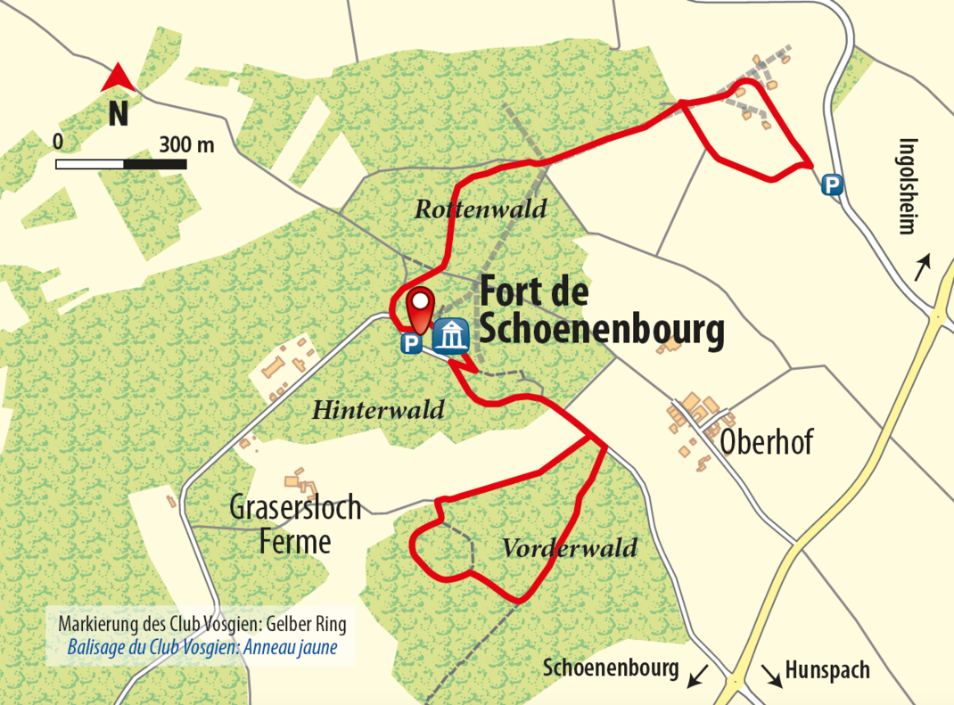
Fort de Schoenenbourg Exploration Route
4 KM I 50 HÖHENMETER I 1:30 STD. DAUER I LEICHT
SHORT DESCRIPTION
This walking route loops around the grounds of Fort de Schoenenbourg (Schönenburg Fort), which is a historical monument of symbolic importance on the Maginot Linie (Maginot Line) that was used to attack and defend. Its strong strategic location offers a wonderful view of the Rhine Valley and the Northern Vosges Hills.
STARTING POINT AND HOW TO GET THERE
| THINGS TO SEE
|
PLACES TO STOP
- Restaurant Chez Massimo (Hunspach), Restaurant Au Cerf (Hunspach)
TOUR DESCRIPTION
The route starts at the entrance to Fort de Schoenenbourg (Schönenburg Fort) on the road called rue Commandant Martial Reynier. The symbol for this walking loop is a yellow circle.
Heading towards the Gefechtsanlagen (Battle Equipment): Starting at the entrance to the Fort de Schoenenbourg (Schönenburg Fort), bear left on the forest path, heading in a northerly direction. You will go through the forest first and then straight ahead along the edge of the forest, where you will be able to enjoy the view of the valley and hills. You will pass through a little gate and come to the meadows that lead to the Gefechtsblöcke (Combat Blocks). Here you will be treated to a spectacular 360° view of the Rhine Valley and the Northern Vosges. Follow the path downhill. Go through the little gate and leave the meadow landscape behind you. Turn left to return to the path that follows along the edge of the forest. Follow the path straight through the forest to arrive back at Fort de Schoenenbourg (Schönenburg Fort), where the route began.
Heading towards “Abri du Graserloch”: Starting at the entrance to Fort de Schoenenbourg (Schönenburg Fort), follow the path to the right, passing by the steps leading to the bunker entrance. Continue on the road called rue Commandant Martial Reynier in the direction of Hunspach. After 400 m, take a right turn so that you are heading towards Bauernhof Graserloch (Graserloch Farm). Turn left into the forest at the next fork in the path. You will then arrive at “Abri du Graserloch”, a Schutzbunker (Protective Bunker). Follow the path straight ahead from here, taking a left turn followed by a right turn to end up back on rue du Commandant Martial Reynier. This road will take you back to the point at which the route started.
Other paths:
Maginot Linie (Maginot Line) Path from Roeschwoog to Bitche (symbol: yellow diamond)
Club Vosgien (Vosges Club) Loops (the red circle loop goes around Schönenburg and the green circle loop goes around Hunspach) – check out the Club Vosgien (Vosges Club) Walking Map, Top 25 No 3814 ET “Haguenau, Wissembourg”
CONTACT
Office de Tourisme intercommunautaire de l’Alsace Verte
Bureau d’information de Niederbronn-les-Bains (Siège)
6 place de l’Hôtel de Ville
67110 Niederbronn-les-Bains
0033 3 88 80 89 70
tourisme (at) alsace-verte.com
www.alsace-verte.com
BUREAU D’INFORMATION TOURISTIQUE DE HUNSPACH
3 route de Hoffen – 67250 Hunspach
Tél. +33 03 88 80 41 46
Copyright photo on this page: ©CCPW
Copyright map: map.solutions GmbH


