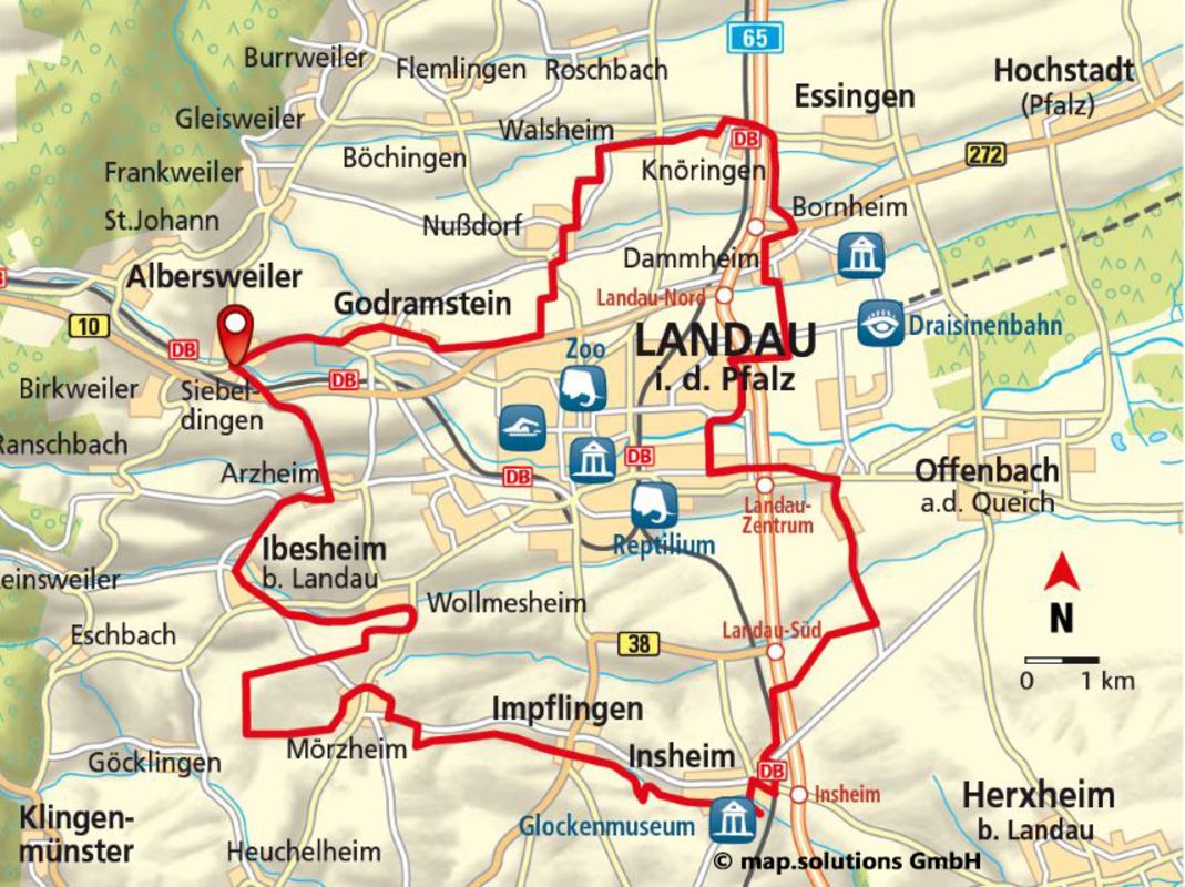
Winegrower Cycle Loop
44.5 KM I ALTITUDE 359 METRES I DURATION 3 HOURS I LEVEL OF DIFFICULTY MEDIUM
SHORT DESCRIPTION:
This magnificent cycle loop is rather on the long side, taking you through idyllic little towns with plenty of opportunities for a pit-stop at the many vineyards along the way. Surrounded by stunning natural scenery, rolling vineyards and picturesque wine-producing spots, Landau in der Pfalz is well worth a visit.
STARTING POINT AND HOW TO GET THERE
| THINGS TO SEE
|
PLACES TO STOP
Ilbesheim, Brennofen Walsheim restaurant, Weincafé Schlupfwinkel wine bar
PEAT BOGS:
Siebeldingen: Cross the B10 and then turn right onto the road called Wiesenstraße after 400 m. Cycle for 160 m and then turn left at the playing field so you are heading north. After another 300 m, cross the road called Bismarckstraße (L511). Turn right and follow the Queichtalradweg (Queich Valley Cycleway) east for 1000 m towards Godramstein.
Godramstein: As you enter the town, take a left turn and head uphill on the following roads: Kapellenweg, Herrmann-Jürgens-Straße and Frankweiler Straße. After 770 m, turn onto Gleisweiler Weg and follow the road uphill, heading north. After 420 m, when you have passed the last property in the town, you will come to a fork in the road. You need to turn right. Follow the road for 610 m and then turn right so that you are heading east. Cross the road called Böchinger Straße (K9) after 270 m and you will arrive at Nussdorf after 1200 m.
Nussdorf: Once you have passed the Wambsganß estate on the road called Lindenbergstraße, turn right onto Schelmengässel, which will take you along the playing field to the Herrengasse road (K8). Turn left and then left again at the Kaiserberg intersection onto the road called “Am heimlichen Eck” after 160 m. Carry on for 150 m and then cross Lindenbergstraße (L512). Proceed along Hintergasse and Kirchstraße until you reach the road called Kirchhohl. Go up Kirchstraße once you have passed the Bauernkriegshaus (Peasants’ Revolt Museum) opposite the church. After 300 m, you will come across a track that you need to follow for a further 140 m, bearing right. Then, take a left and head north. Carry on for 230 m (at the halfway point you will pass an oil pump on the right-hand side) and then take a right turn so that you are going east. The path you are cycling on at this point is 270 m in length and covered in coarse gravel. You will end up at the Wasserpumpstation (Water Pumping Station), where you need to turn left and head downhill in the northerly direction. Note that once you are 340 m (halfway) along the downhill path, you will need to take a right turn ahead of the first property in Walsheim.
Walsheim: After 300 m, you will come across the Raiffeisen property on Nussdorfer Straße (K55). Cross the road and proceed along Allmendstraße for 110 m, before turning left onto Hauptstraße after Weingut Pfaffmann (Pfaffmann Wine Estate). Cycle east on this road for 430 m until you reach Schulstraße, where you should take a slight right. After 250 m, ride through the underpass on the L516. On the other side, turn left and then right after another 30 m so that you are heading east. Follow the road for 730 m until you find yourself on the road called Am Mühlrain in Knöringen
Knöringen: Cross over the intersection and proceed up Kirchstraße, before turning left onto Hauptstraße in 250 m. Cycle for 190 m until you reach Bahnhofstraße (L513) and then take this road until you arrive at the train station in 270 m. Go over the tracks and the bridge over the A65. Turn right onto the track road running alongside the A65, heading south. After 1100 m, you will come across the L272. Cycle on the track running in parallel to the road, heading towards the A65. After 430 m, cross the bridge over the L272. Take a right turn in 110 m so that you are ready to head south towards Dammheim in another 400 m.
Dammheim: After 310 m, you will arrive at the Wein- und Sektgut Wambsganß (Wambsganß Wine Estate) on the main road, Speyerer Straße. Cross this road and proceed along Dorfstraße. When you get to the intersection, cycle up Schmiedstraße and turn left onto Dorfstraße. When you reach the road called Alte Bahnhofstraße, follow it to the right, heading south, for 800 m until you get to Kreisstraße country road (K34). After another 250 m, take a right turn after the Kleingartenanlage Horstring (Horstring Allotments). You may want to take the opportunity to follow the cycle path through the park-like space that even has a children’s playground. Head west along the road called Am Kugelfang under the A65, passing by the Jugendfreizeitanlage (Youth Centre). After 670 m, take a left turn onto the Horstring track and head south. Follow it for 950 m to the traffic lights on Dresdener Straße and turn on Stettiner Straße, heading towards La Ola Parkplatz 1 (Car Park 1). Turn right once you have reached the Queich River in 80 m. Cycle along the path for 270 m as far as the Queichanger (Queich Village Green), where you should turn left so you are heading south. In 530 m, you will reach the road called Alte Hintergasse in Queichheim.
Queichheim: Follow the main road, Queichheimer Hauptstraße, until you reach the traffic lights at the L509/Mörlheimer Hauptstraße intersection.
Mörlheim: Cross the intersection and continue cycling on Mörlheimer Hauptstraße. After 160 m, follow the road to the right through An den Herrenäckern and An den Thoräckern, which are roads with traffic-calming measures in place, until you end up back on the Mörlheimer Hauptstraße at the Evangelische Kirche (Protestant Church). Cycle for another 170 m to the road called Offenbacher Straße, where you will have reached the Tobacco Route. Follow this route for 290 m until you arrive at Mörlheimer Bahnhof (Mörlheimer Train Station). At this point, you need to turn right towards the motorway (heading west). After 690 m, you will come to an electricity pylon. Turn left here and head uphill. You will see the next milestone on your right above the motorway – a privet hedge running alongside the rows of vines for around 180 m. To reach this milestone, turn right after 410 m and then left after another 340 m. The tarmac path will end after this row of vines and you will be cycling on a gravel path for approximately 800 m until you reach the bridge over the A65. Once you have crossed the motorway, take a left turn and head south. In 1 km, you will come to the road called Offenbacher Straße (K21) and start to follow the cycle path alongside it that leads to Insheim.
Insheim: Cross the railway bridge and after 200 m turn left onto Bodelschwingstraße. Stay on this road until you reach the train station. Once you have crossed the road called Bahnhofstrasse (L543), you will find yourself on Martin-Luther-Straße. Turn right on this road after 100 m. You will be heading downhill for 180 m and then you need to turn left onto Sandweg. Carry on down this road until you merge onto Kandeler Strasse. Head right on this road as far as Rohrbacher Straße (K21), which you will need to cross. Continue on the road called Halbengartenstraße. This road will become Ketteler Straße after a while, at which point you need to cycle for another 500 m to Friedhofstraße. Turn right. After 40 m, Sportplatzstraße will take you left along the Quodbach Stream, past the playing field and tennis court as you leave the town. After 450 m, take a left turn across the Quodbach Stream and turn right towards Impflingen after 120 m. Once you have passed Birkenhof, you will find yourself on the road called In der Kuhweide.
Impflingen: Turn right once you reach the road called Bruchgasse. If you want to end the route here, you can head back to Landau by taking the following roads: Bruchgasse, Wiesenstraße, Friedhofstraße. You will then need to cycle parallel to the B38. When you reach the Schleidgraben River, cross the B38 and then proceed on the cycle path alongside Weißenburger Straße, Goethepark, An 44 and Langstraße up to Rathausplatz. Otherwise, continue on Bruchgasse for 350 m until you get to Hauptstrasse (B38). Cross this main road and follow the road called Obergasse for 250 m as far as Herrlichstraße. Turn right here and then take a left after another 75 m to turn onto the track leading to Mörzheim. From Sonnenberghof, just before you leave the town, follow the slightly uphill path west. After 590 m, turn right and cycle uphill for 100 m. Take a left on the slightly higher path running in parallel. After 880 m, you will cross a track running in a north/south direction. The path you are on will end after another 350 m and you will need to cycle uphill to the right from 80 m. Then take another right turn. After 160 m, you will pass the tank barriers on the left. In another 190 m, you will see the Aussiedlerhof Joachim Farm as you enter the town of Mörzheim on the road called Impflinger Straße (K7).
Mörzheim: Confident cyclists can take a left turn and follow the alternative route, which features information points and boasts a magnificent view. For families with children and any other less confident cyclists, we recommend crossing Impflinger Straße and heading left on the track that leads to the town after 230 m. Turn right once you have reached the road called Brühlstraße in 520 m. After 70 m, you will come to the NABU Hirtenhaus Nature Conservation Centre. Turn left there onto Untergasse. Travel via the roads called Paulgasse and Haufenstraße until you get to Weingut Stentz (Stentz Wine Estate) on Mörzheimer Hauptstraße (L510). Cross this main road and take Johann-Thomas-Schley-Strasse as far as the Kindergarten (Childcare Centre), where you should turn left and then right onto Raiffeisenstraße after 90 m. Proceed down this road and Göcklinger Weg. From the Kuntz & Sohn estate as you leave the town, the path will take you uphill for 830 m until you reach the intersection on the ridgeway. Take a right turn and head north. After 700 m, you will reach a single tree at an intersection, where you should turn so you are heading east. Cross Kreisstraße (K6) after 800 m and turn left onto the uphill path after another 760 m. Once you have cycled 330 m, you will have crossed the ridge. Turn right to enter the town of Wollmesheim.
Wollmesheim: The path will take you past Weingut Ludt (Ludt Wine Estate). Turn left after 350 m and cycle as far as the road called Straße Am Neuberg, where you should head right until Pinselgasse. Head left on this road until you get to Wollmesheimer Hauptstraße. If you want to end the route here, the path will take you back to Landau through the Birnbach Valley. Once you have crossed the L510, the path will take you alongside the Birnbach Stream as far as the road called Dörrenbergstraße. You will then need to head through the new housing estate (Quartier Vauban) and Goethepark, before proceeding along An 44 and Langstraße up to Rathausplatz. Head left on Wollmesheimer Hauptstraße until you reach the edge of the town on the L509. Just before the L509, take a left turn and you will come to Kreisstraße (K6) at the entrance to Ilbesheim after 850 m. Turn right and head into the town. Cross the L509 and cycle through Ilbesheim, a beautiful place where wine is grown. Head past the Rathaus (Town Hall) and the Grundschule (Primary School), leaving the town towards Landau-Arzheim. Turn right just as you enter the town and follow the road until it merges onto Kalmitstraße to the left. At the end of that road, first head to the right and then turn down the next road on the left. You can then cycle through the vineyards in the direction of Siebeldingen so you end up back where you started.
CONTACT
SÜDLICHE WEINSTRASSE E.V.
An der Kreuzmühle 2, 76829 Landau
Telefon +49 (0)6341 940-407
info (at) suedlicheweinstrasse.de
www.suedlicheweinstrasse.de
Copyright photo on this page: Ralf Ziegler, Südliche Weinstrasse e.V.
Copyright map: map.solutions GmbH