
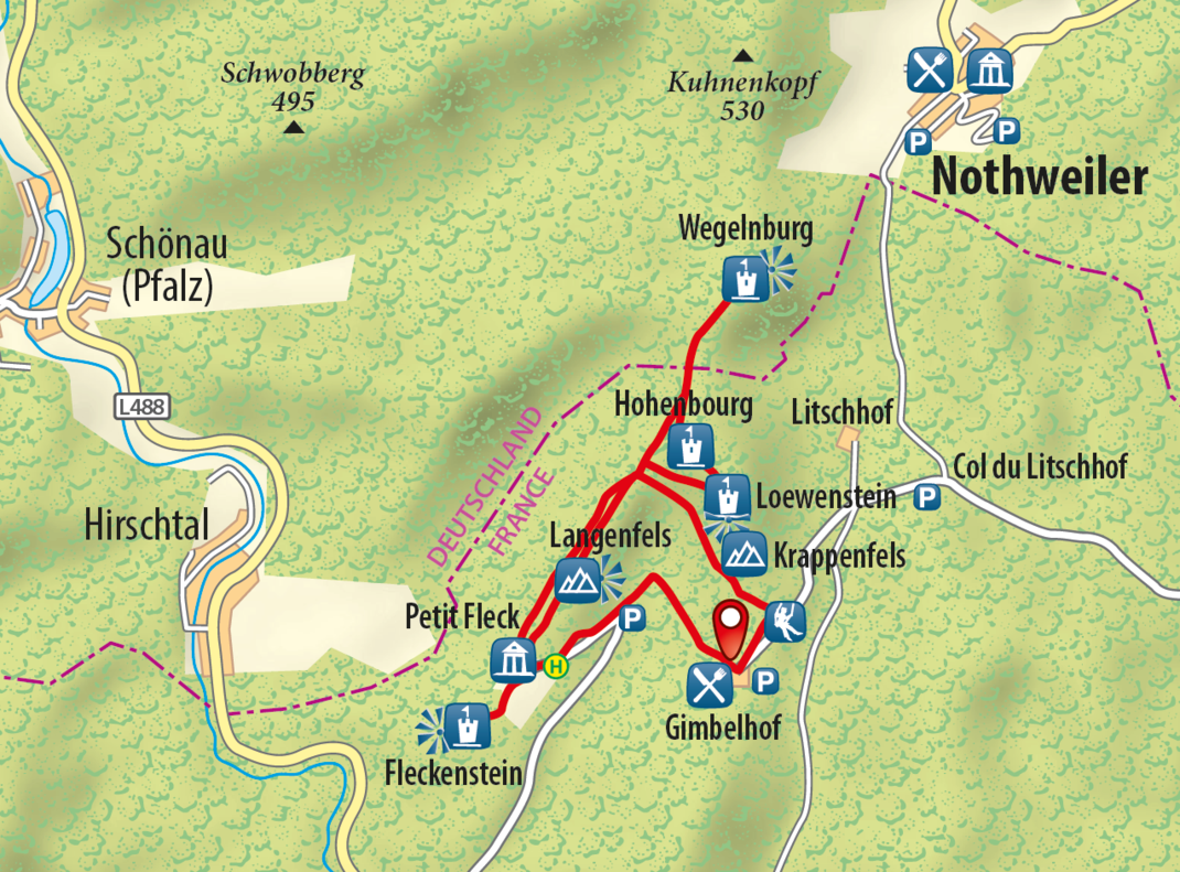
Route of Four Castles

6,5 KM I 305 HÖHENMETER I 2:30 STD. DAUER I MITTEL
SHORT DESCRIPTION
This walking loop takes in the impressive ruins of four Medieval rock castles (Fleckenstein, Loewenstein, Hohenbourg and Wegelnburg), offering fascinating insights into their history and spectacular views of one of the most beautiful regions the Northern Vosges have to offer.
STARTING POINT AND HOW TO GET THERE
| THINGS TO SEE
|
PLACES TO STOP
- Hôtel-Restaurant Gimbelhof, Café des 4 Châteaux (Fleckenstein)
TOUR DESCRIPTION
Starting at Gimbelhof, follow the red disc symbol along the meadow. Turn left just after the playground and head uphill via the “col du Schlossberg” (473 m). When you get there, follow the red/white/red bar symbol to the Ruine Loewenstein (Loewenstein Ruins), which are also known as the Château de Lœwenstein. The castle, which was built in the 13th century, was an imperial fiefdom until 1283, before being occupied by marauding knights until it was destroyed in 1386.
Keep following those red/white/red bar symbols until you reach Hohenburg Castle in around ten minutes. Don’t forget to marvel at the amazing view from this point. This castle was built in the 13th century and renovated at the start of the 16th century so it could be turned into a residence. A lovely Renaissance gate from this period still stands.
Next, walk down the hill the castle stands on and take a look at the small Maidenbrunnen Spring. When you are ready to get going again, head in the direction of the German/French border. Just before you reach the border, the path merges onto a flat and level piece of land called “Stöckelgarten” and briefly crosses the border at the landmark called the “Wilhelmstein”. You will then walk past the Kroetenstuhl Rock and arrive at the Ruine Wegelnburg (Wegelnburg Ruins) a few minutes later. Standing at an altitude of 572 metres, these are the highest castle ruins in the Palatinate.
You will now need to go back a little way on the same path. Turn right at the Maidenbrunnen Spring (symbol: red bar) and walk to Fleckenstein via the “col du Schlossberg”. After you have visited the Burgruine Fleckenstein (Fleckenstein Castle Ruins), walk on the Köhlerpfad (Coal Merchant Path) (symbol: yellow circle) and head back to Gimbelhof (symbol: red/white/red bar).
Alternative route: You can head back to the starting point in Fleckenstein from the “col du Schlossberg” via the incredible Felsenpfad (Rock Path) (follow the red triangle). Please note: We do not recommend taking this path if you have small children with you or if the weather is wet.
CONTACT
HOTEL-RESTAURANT GIMBELHOF
Lieu-dit Gimbelhof – F-67510 LEMBACH
Tél. +33 (0)3 88 94 43 58
info (at) gimbelhof.com
www.gimbelhof.com
Office de Tourisme intercommunautaire de l’Alsace Verte
Bureau d’information de Niederbronn-les-Bains
6 place de l’Hôtel de Ville
67110 Niederbronn-les-Bains
0033 3 88 80 89 70
tourisme (at) alsace-verte.com
www.alsace-verte.com
Bureau d’information touristique de Sauer-Pechelbronn
2 route de Bitche
67510 Lembach
0033 3 88 86 71 45
CHÂTEAU FORT DE FLECKENSTEIN
Lieu-dit Fleckenstein – 67510 LEMBACH
Tél. +33 (0)3 88 94 28 52
info@fl eckenstein.fr
www.fleckenstein.fr
Copyright photo on this page: © ADEAN/ M. Anglada
Copyright map: map.solutions GmbH


