
At the Heart of the UNESCO Biosphere Reserve
12 KM I 300 HÖHENMETER I 3 STD. DAUER I MITTEL
SHORT DESCRIPTION
Prepare to be wowed by the stunning nature and fascinating culture that the Pays de Bitche has to offer as you walk. There are plenty of lovely ponds, tranquil forests, spectacular vantage points and impressive castle ruins to be admired on this route through the heart of a protected natural landscape.
STARTING POINT AND HOW TO GET THERE
| THINGS TO SEE
|
PLACES TO STOP
- Restaurant L’Arbre Vert in Baerenthal
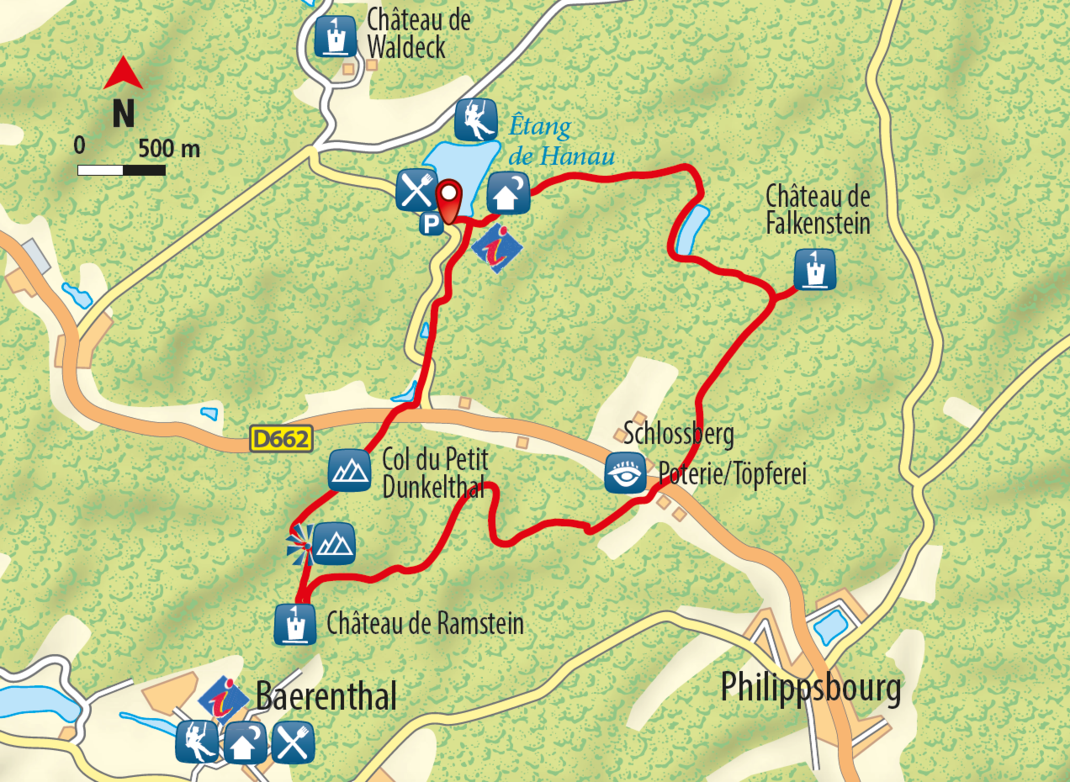
TOUR DESCRIPTION
The route starts off at the Damm des Hanauer Weihers (Hanau Lake Dam) and goes on from there in the direction of Lieschbach Pond, passing the Kachler Pass (symbol: blue cross). Go around the pond on the right-hand side and keep following the path (symbol: blue cross) until you come across the Ruine Falkenstein (Falkenstein Ruins).
After the ruins, stay on the same path for a little bit longer. Turn left when there is a fork in the path (symbol: yellow triangle) and head towards Schlossberg’s Forsthaus (Schlossberg Forester’s Lodge). Cross the D662 at this point on the Hoellenderthal-Weg (Hoellenderthal Path) (symbol: yellow circle). After the little bridge, take a right turn (symbol: yellow circle) until you reach the Grand Dunkelthal Mountain Pass.
Walk on from here to the Ruine Ramstein (Ramstein Ruins) (the path is not signposted at this point), where you have the chance to explore the castle and enjoy the panoramic view. Next up on the route is the Petit Dunkelthal Mountain Pass (symbol: yellow rectangle). Stop and admire the beautiful view here too.
Head downhill towards the Hanauer Weiher (Hanau Lake) until you get to the D662. Cross the road and stick to the path as it takes you through the meadow and on to the next road (D162). Walk along the road to the left for a short stretch (around 250 metres). Turn right on the bend ahead of the bridge (symbol: yellow rectangle). After 400 metres, you will come to another bend. Turn left onto the path (symbol: yellow rectangle still), which you can follow all the way back to where the route started.
CONTACT
OFFICE DE TOURISME INTERCOMMUNAL DU PAYS DE BITCHE
2 Avenue du Général de Gaulle • F-57230 BITCHE
Tél. +33(0)3 87 06 16 16
contact (at) tourisme-paysdebitche.fr
www.tourisme-paysdebitche.fr
Copyright photo on this page: © G. Pecqueur
Copyright map: map.solutions GmbH


