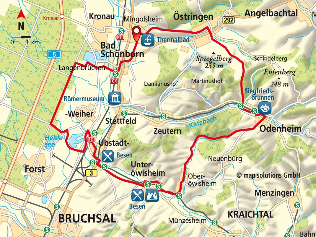
Wellness Route
38.8 KM I ALTITUDE 213 METRES I DURATION 3.43 HOURS I LEVEL OF DIFFICULTY EASY
SHORT DESCRIPTION:
The clue is in the name of this route! You can expect a relaxed loop around unspoilt nature reserves and wetland landscapes, with views across the vineyards and a stop-off at Hardtsee Lake for a leisurely swim, boat trip or sunbathe. A visit to the Bad Schönborn Thermalbad (Thermal Spa) at the end of the route is the very embodiment of wellness.
STARTING POINT AND HOW TO GET THERE
| THINGS TO SEE :
|
PEAT BOGS
The route starts off at the Haus des Gastes at the Thermalbad (Thermal Spa) in Bad Schönborn Mingolsheim. Take the road called Kraichgaustraße and head out of the town. At the end of the road, carry on straight ahead to Östringen on the tarmac track. Take a right turn as you enter the town and then take the next left onto Allmendstraße. At the end of that road, take a right turn and then the next right opposite the one-way street. Go straight over Hauptstraße and then carry on uphill. At the four-way intersection, keep going uphill onto Hohlweg. Once you get to the top, go straight ahead and pick up the tarmac path again. Cycle straight on at the four-way intersection (Kilometre 6; Gallusbildhäusel Wayside Shrine) and then take a slight right at the next fork, following the tarmac path downhill in the direction of Odenheim. Turn left towards Hauptstraße and then head right on this road. Go straight over the L552 and the tracks. Take a left at the T junction and then turn right onto the footpath after another 20 m so that you are cycling alongside the Fabrikgebäude (Factory Building). When the footpath comes to an end, turn left and follow the road alongside the stream until you reach Hauptstraße. Bear left on this main road and then turn right onto the cycle/footpath after the bridge. Bear right to leave the cycle/footpath in the town centre and cycle to Hauptstraße. Take a slight right turn on this main road and carry on straight ahead at the junction in the direction of Oberöwisheim. As you leave the town, you will notice that a cycle/footpath appears on the right. At the end of this path, follow the narrow street round slightly to the right. Cycle through the forest, shortly going downhill, and then along through the valley to Oberöwisheim. Carry on straight ahead at the junction and then bear right over the wooden bridge to Hauptstraße. Turn left on this main road and then take the next left towards Neuenbürg, before taking an immediate right onto Albert Schweizer Straße. At the end of that road, turn left and head over the tracks and past the stopping point in the direction of Unteröwisheim. Cross Hauptstraße and continue cycling along the cycle/footpath. Take a right turn at the next junction and cycle into the town in the valley. Turn right underneath the Schloss (Castle) and then cycle through the allotments. Go straight ahead and over Hauptstraße when you come to the stopping point. Turn right at the L554 and proceed on the cycle/footpath alongside the road towards Ubstadt. As you enter the town, take a right and head downhill, passing the stopping point and the football field. Follow the road called Wohnstraße around to the left. Go straight on at the traffic lights and then turn right onto the cycle/footpath straight after the tracks. Take a left turn at the stopping point and follow Weiherer Straße to Bahnhof Ubstadt-Weiher (Ubstadt-Weiher Train Station). Go through the underpass and follow Bahnhofstraße straight on. Take a right onto the cycle path from Hauptstraße and bear right at the junction that follows, cycling up and over the bridge in the direction of Forst. Turn left and cycle along the L555. Take a right turn after about 800 m and follow the tarmac path, which you will find will soon be alongside the Baggersee (Quarry Pond). When you reach the Campingplatz (Campsite), turn left towards Hauptstraße and proceed on the cycle path in the direction of Hambrücken. In the forest, turn right onto Kronauer Allee and follow this road towards Kronau. At Kilometre 32.5, turn right in the direction of Bruchsal and cycle to Langenbrücken. Carry on straight ahead at the playing field. Cross the stream and cycle along Dammstraße up to the stopping point. Go through the underpass and straight on into the town centre. Once you get there, bear right and then take the next left turn onto Pfalzstraße. Turn right onto Hafnerstraße and then straight over Hauptstraße. Follow the road called Östringer Straße. Cross the B292 and cycle along the cycle/footpath as far as Mingolsheim. Follow Pestalozzi Straße to Hauptstraße and then head right on this main road. Take the next left onto Falltorstraße and head back to where the route started.
CONTACT
Kraichgau-Stromberg Tourismus e.V.
Melanchthonstraße 3, 75015 Bretten
Tel: +49 (0) 7252 / 9633-0
info (at) kraichgau-stromberg.com
www.kraichgaustromberg.com
Copyright photo on this page: Kraichgau-Stromberg-Tourismus-e.V. Oestringen Tiefenbach Kreuzbergsee
Copyright map: map.solutions GmbH