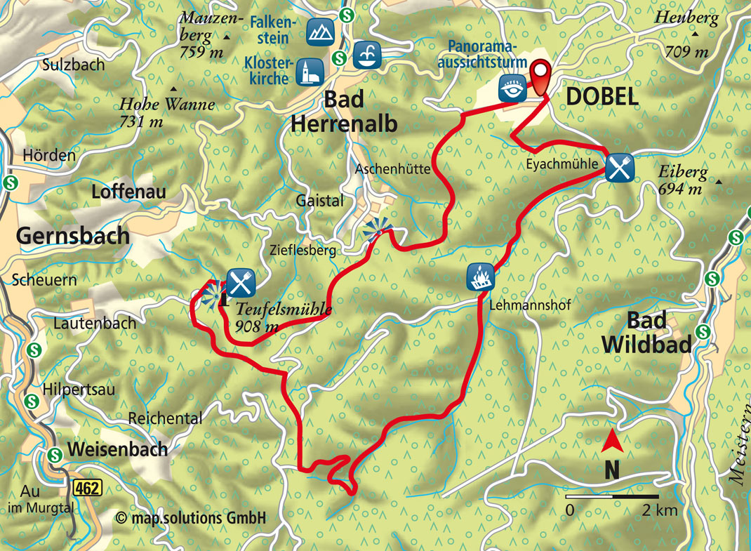
Dobel/Teufelsmühle Mountain/Eyach Valley Panoramic Route
33 KM I ALTITUDE 800 METRES I DURATION 3 HOURS I LEVEL OF DIFFICULTY MEDIUM
SHORT DESCRIPTION:
This route is perfect for anyone with experience on a pushbike or electric bike. It involves a long uphill stretch to Teufelsmühle Mountain and a speedy descent through the rough Brotenau and Eyach Valley against a backdrop of stunning views across the Alb and Murg Valley. Teufelsmühle and Eyachmühle also make for two wonderfully quaint places to stop along the way.
Starting point and how to get there
| Things to see
|
EINKEHRMÖGLICHKEITEN
- Höhen-Gasthaus „Teufelsmühle“ und im Tal-Gasthaus „Eyachmühle“
PEAT BOGS:
We cycle along little tarmac forest roads (that cannot be accessed by cars) on our gentle uphill route from Dobel, as far as the Weithäusle Viewpoint, passing the Stierhütte cabin and taking in the spectacular views. At the Weithäusle, there is an eight-way forest intersection, where we need to follow the Hahnenfalzweg Path, which also follows the route of the Westweg Path. The views from this point are truly stunning, culminating in what you can see from the Schweizerkopf-Hütte Viewpoint. From here, we continue on the Hahnenfalzweg Path until we reach the steep Hinteres Steigle Track, which leads down onto the Ächtlersweg Path. We take a left turn and head up to the restaurant called Hahnenfalzhütte (where it is sometimes possible to stop). After another 600 m, we turn right at the hairpin bend and head towards Teufelsmühle Mountain. We pass by the Steinerne Sitzbank (Stone Bench) and come to the road that connects Loffenau to Teufelsmühle Mountain in around 1.7 km. After a left turn, it is only another 200 m up to Teufelsmühle Mountain, where there is a guest house and viewing tower. We proceed towards the Ahornwasen on a gravel path, but about 100 m before we reach the cabin we turn left onto the uphill path to the Langmartskopf-Hütte cabin. At this point, it is possible to see the Hohlohturm (Hohloh Tower) and the other towers on the Hornisgrinde Mountain further in the distance. We head south on a slight incline until we reach the Kreuzlehütte cabin, where a lovely meadow makes for a nice place to stop. We will be relying mainly on the brakes for the rest of the route, with the narrow gravel paths taking us down to the Brotenau Valley, where a forester’s lodge was once nestled in a romantic setting. Carrying on through the valley, we pass the Rotwasserhütte cabin, where the red-brown overspill from the Wildsee Marsh flows into the Brotenau Stream. In the Große Wiese (Large Meadow), the Brotenau and Dürreych Streams combine to form the Eyach. We then take a short detour to Rastplatz Lehmannshof (Lehmannshof Rest Stop), where there is barbecue facilities and a playing field. On the 5 km remaining before we reach the Eyachmühle guest house, we pass by old stone quarries, wetlands with water lilies and old hay barns. The Eyachmühle guest house is the perfect place to refuel ahead of the uphill climb through Mannenbach Valley. Upon leaving the guest house, we take the road to Dobel and then turn left onto the Unterer Mannenbachweg Path after around 200 m. After approximately 2 km, we cross over the Carl-Postweiler-Weg Path and then turn right onto the Lehmannsweg Path after another 500 m. We will then come to the south-west of Dobel via the Kastanien-Kreuzung intersection. Once we reach Dobel, we head along the road called Wildbader Straße until we arrive back at the Kurhaus.
CONTACT
Tourismusbüro der Gemeinde Dobel
Neue Herrenalber Str. 11, 75335 Dobel
Tel. +49 (0) 7083 / 74513
kontakt@dobel.info
www.dobel.de
Copyright photo on this page: Teufelsmühle © isocont GmbH
Copyright map: map.solutions GmbH