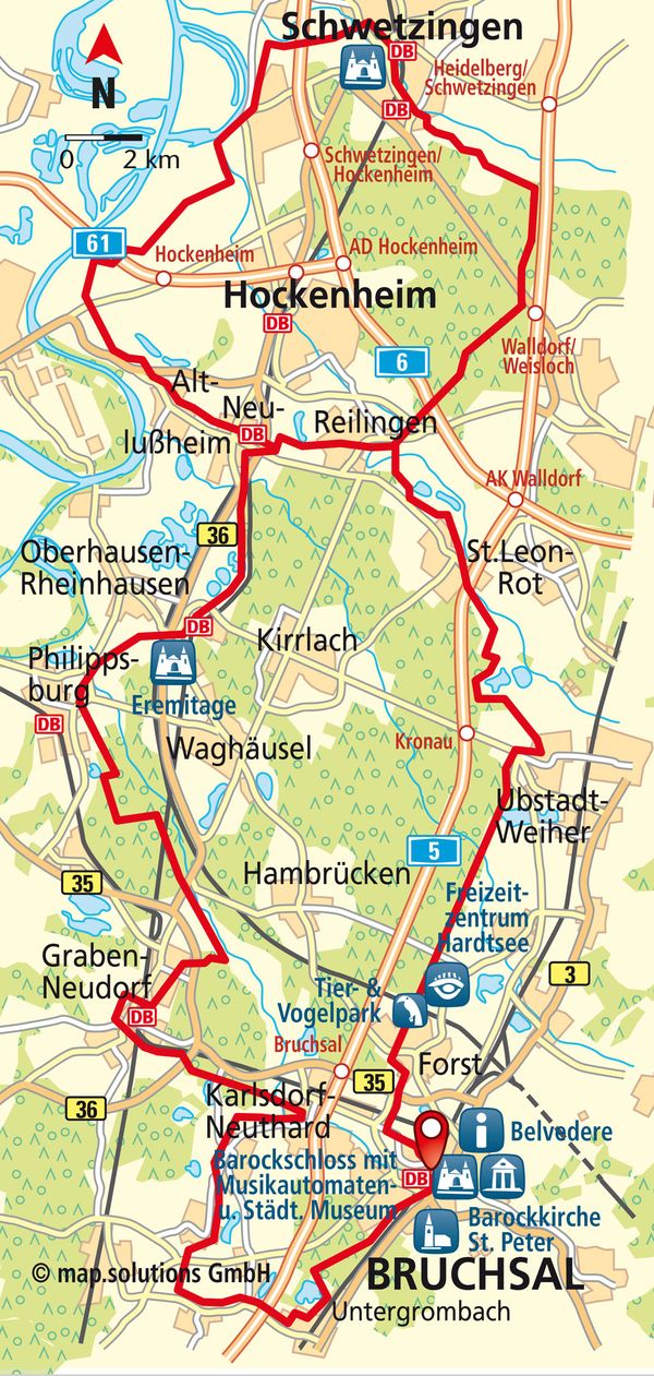
Asparagus Route
108 KM I ALTITUDE 171 METRES I DURATION 7 HOURS I LEVEL OF DIFFICULTY MEDIUM
SHORT DESCRIPTION:
Hop on your bike and cycle through the Rhine Valley, taking in the stunning scenery in one of Germany’s largest asparagus-growing regions. During asparagus season, you will be able to spot lots of helpers working hard to cut off the spears in the fields. Farm shops provide a delightful setting in which to try some tasty culinary delights.
START / ANFAHRT
Places to stop
Things to see
|
|
PEAT BOGS
You can choose whether you would like to go for the route spanning approximately 75 km via Reilingen or the full-route version covering 108 km via Schwetzingen depending on your experience and how you are feeling. The route starts at the cycle path intersection at the corner of Amalienstraße and Luisenstraße by the Lutherkirche (Luther Church) in Bruchsal. From there, you will need to head in the direction of Untergrombach. Start by crossing the B35 and then a railway line. Shortly after that, you will need to cross the railway line, before taking an immediate left turn. The cycle path passes some allotments in the Büchenauer Forest. You should note that the paths are unpaved at this point. Follow the main footpath to the left so that you are heading towards the Karlsruhe borough of Durlach/Untergrombach. You will need to carry on straight ahead for quite some time, before following two 90° bends round. You will end up at the car park for the Untergrombach Baggersee (Quarry Pond). Carry on into the town and take the third right onto Wendelinusstraße. At the roundabout, take the third exit (Im Sand) to Kreisstraße 3501. You will come to the cycle path, which you need to follow to the right in the direction of Büchenau. If you would like to take a detour and visit the asparagus farms, follows the sign for the town centre (“Ortsmitte”) to the right. Note that the Asparagus Route takes you past the entrance to the town of Büchenau and onto a track on the right shortly afterwards. Take an immediate left towards Staffort and proceed along Hauptstraße. As you enter Staffort, you will be on Büchenauer Straße (the road that passes through the town) and you should stay on this road until you leave the town again. Follow the square on-route cycling signs. These will lead you over the Pfinz River to Spöck via the Herrnauhof and Bernhardsäckerhof Farms. In Spöck, you need to take a slight right onto Brunnenstraße as soon as you enter the town. Take a sharp right onto Henhöferstraße when you reach a small car park and then turn left onto the cycle path that runs parallel to Pfarrweg. This will take you to Kirchstraße, which you should cross before continuing to head right as far as the bridge. After the bridge, take an immediate left onto an unpaved path alongside the Pfinz River. Follow this path until you reach the town of Neuthard. Pass the residential estate and cross Spöcker Straße. Keep cycling alongside the stream. The Vogelpark (Bird Park) on the right-hand side is a great place to stop for a short rest. Once you are ready to continue, cross the K3529 and follow the stream until you need to turn right as you leave the town. Then take the first road on the left. After two intersections, take a right turn onto the road called Im Entenfang. Just before the food store, turn left onto the tarmac track running alongside the K3528 and cross the bridge over the Hardtgraben River. Head right alongside the stream straight away and cycle to the road passing through Karlsdorf. Follow the road round to the left as far as the church. Next up, you will come to two roundabouts. Leave the first one at the second exit (straight on) and the second one at the third exit, joining Bahnhofstraße. Cross the Saalbach Stream and turn left onto Kohlfahrtstraße. Follow the on-route cycling signs until you have crossed back over Saalbach Stream. From this point, cycle on the tarmac path and follow the on-route cycling signs, passing the Friedhof (Graveyard) and then heading right. At the junction, take a left turn into the forest. Once you have passed by two little bridges, take the first opportunity to turn right onto the road called Kammerforst. Follow the on-route cycling signs, cross the K3529 and pass Badesee Siebenerlen (Siebenerlen Bathing Lake). The Asparagus Route will now take you straight through the forest for a while. After you have crossed the B36, you will come to a railway line, which you should follow to the left. Cross the Pfinz River when you come to it. Bear right towards Graben and then turn right onto Kirchstraße. Take another right onto Schulstraße and then a left onto Schloßstraße. When you reach Hauptstraße, cross at the pedestrian crossing and cycle straight on until you are out of the town. Turn right at the first opportunity (Germersheim cycle path signs), crossing the bridge and continuing until you reach the courtyard in front of Festhalle Graben (Graben Hall). From there, cycle along the road called Untere Reut until you reach Fichtestraße, which merges onto Pestalozzistraße after a bend to the left. Once you have passed the Gemeindeverwaltung (Local Government Building), take the next road on the right to join Bahnhofsring and carry on to the train station via the main road (Hauptstraße). Go through the underpass and cross the big road called Heidelberger Straße. Carry on to the left towards Neudorf (Heidelberg/Hambrücken cycle path signs). Follow the on-route cycling signs down Weinheimer Straße to the right and across the Saalbachkanal (Saalbach Canal). Keep going until you have crossed the L557. At that point, turn right onto Haydnstraße and cycle past the Vogelpark (Bird Park), turning right into the forest immediately afterwards. Cross the B35. Follow the signs to the left towards Speyer/Hambrücken. After the woodland, follow the hairpin bend round to the left and then carry on alongside the Saugraben Stream. Cross the B36 (carefully). Turn right and head through the forest until you have crossed over the railway line. Take a left turn and continue through Wald Molzau (Molzau Forest) in the direction of Philippsburg, passing the Hebelsee Lake, until you have crossed the K3535. At this point, you need to turn right and then immediately left. Philippsburg will appear on your left. At the next junction, bear left and cycle to the L555, which you should follow to the right for around 2.5 km. Cross the B36. The next town you will come to is Waghäusel. Following the cycle path on the right-hand side of the road, turn onto the road called Bischof-von-Rammung-Straße and take a detour to the Eremitage (Hermitage). Once you are back on the main route, head left and then immediately right, going straight through an underpass and staying on the old B36 road for 5 km until you come back to the B36. Cross this road and the railway lines before heading right towards Neulußheim straight away. Cycle around the edge of the town for about 700 m and then turn right onto Siemensstraße. When you get to the big intersection on St. Leoner Straße, you have two options: You can stay on the “Short Asparagus Route”, which will take you back towards Bruchsal at this point, or you can embark upon the “Long Asparagus Route”. Heading left towards Speyer, the long route will take you to Schwetzingen via Altlußheim, Hockenheim and Ketsch. If you cycle right to Walldorf/St. Leon-Rot, you will shorten the route by heading in a south-easterly direction to St. Leon-Rot via Reilingen and then returning to Bruchsal. Long route: Pass through Neulußheim to the left, heading towards Speyer, and continue until you reach Altlußheim. Once you have passed the Autovision Museum, continue on Hauptstraße in the direction of Hockenheim/Ketsch. After the intersection on Kirschenstraße, turn right at the junction onto Wiesenweg. Cross the B39, turn left straight after the farm and then take the second turning on the right. You will then be able to enjoy a 6-km stretch through the Naturschutzgebiet (Nature Reserve). Cross the L722 and take the second left followed by the second right. From this point onwards, continue straight ahead up to the sign at the Siegelhain settlement. The path bends round to the right here towards Hockenheim and crosses the A61. Once you have crossed the road, take the first right followed by an immediate left turn. Carry on straight ahead for around 2 km until you reach Hubwiesen. There, the next sign will show you the way to Schwetzingen – straight ahead until you come to the Kraichbach Stream. Take a left turn to the K4250 (Speyerer Straße) here. Continue to the right towards Schwetzingen/Ketsch. You will pass the Anglersee Lake and come to the intersection between Speyerer/Hockenheimer Straße. Take a left turn here and then turn right onto Brühler Straße immediately afterwards. Follow the sign directing you straight on towards Schwetzingen. Take a right turn off Brühler Straße and onto Spießstraße. Turn onto Karl-Marx-Straße from the roundabout. Cross Mannheimer Straße before taking a left then right turn onto the path called Brühler Pfad. At the end of the path, the sign points towards Schwetzingen to the right, taking you across the A6 and railway line. You will find yourself approaching Schlossgarten Schwetzingen (Schwetzingen Castle Grounds) from behind. Turn left onto Schloßgartenweg, which will lead you around the castle grounds. Once you have passed the Wasserspielplatz (Water Playground), continue to the right via Kronenstraße and Hebelstraße until you reach the Schlossplatz (Castle Square). Turn left at the Spargelfrau (Asparagus Lady Statue) and continue to the train station. Follow the tracks to the right and pick up the cycle path running parallel to the railway line, which leads on in the direction of Oftersheim. The cycle path bears slightly to the right and merges onto Franz-Dusberger-Straße. Cross the Leimbach Stream and turn left onto Mannheimer Straße at the end of the road. From this point, follow the signs for the Rheintalradweg (Rhine Valley Cycle Path) (Radfernwegenetz, Long-Distance Cycle Path Network), which now runs alongside the Asparagus Route. Once you are beyond the railway underpass, you will come to Oftersheim. Stay on Mannheimer Straße until you have the opportunity to turn left onto Mozartstraße (leave the Rhine Valley Cycle Path). Bear right and head to Am Alten Meßplatz. Cross the big road called Heidelberger Straße (L544). Follow the signs until you are leaving Oftersheim in the direction of Sandhausen. Head towards the farms. You will then find yourself back on the Rheintalradweg (Rhine Valley Cycle Path). Follow the signs for around 2.5 km as far as the A5. Head to the right. The path will lead you through woodland (Schwetzinger Hardt) measuring some 8 km in length in the direction of Reilingen. You will need to cross the L291, the A6 and then the L723 on the way. The next main sign on the other side of the road beyond the Friedhof (Graveyard) points towards St. Leon-Rot/Bad Schönborn. The route overlaps with the Short Asparagus Route again here, heading towards Neulußheim. Cross the Kraichbach Stream again on Burgweg and stay on the path for a little while longer. Continue in the direction of St. Leon, passing the St. Leoner See (St. Leon Lake). Make sure that you stay to the left of the residential estate at all times. At the intersection between Roterstraße and Marktstraße, take a right turn towards Bruchsal. Turn left immediately afterwards and continue until you come to cross the A5. The signs from this point will take you through forests and meadows, along the edge of the woodland and past a bathing lake on the way to Kronau (you will leave the Rhine Valley Cycle Path once more). Once you are in the town, take the second right onto Robertstraße and carry on straight ahead as far as Kirrlacher Straße. From there, follow the sign to the right and then the signs on to Bruchsal. When you come to the big traffic lights, you will find yourself back on the Rheintalradweg (Rhine Valley Cycle Path). Cross the L555 and cycle towards Forst for around 10 km on Kronauer Allee. Once you have crossed the L556 intersection (Burgweg), leave the Rheintalradweg (Rhine Valley Cycle Path) again and bear right. From this point, follow the signs
past the Spargelhof (Asparagus Farm), through the Wendelrot industrial estate and straight on to the Sportzentrum (Sports Centre) and the entrance to the Castle Grounds. In Bruchsal, follow the signs for the Bahnhof (Train Station) and Rendezvousplatz until you reach the Lutherkirche (Luther Church), which is where the Asparagus Route started. We recommend that you divide this route up into smaller chunks. That way even less experienced cyclists can enjoy the adventure!
CONTACT
Touristinformation Bruchsaler Tourismus, Marketing & Veranstaltungs GmbH
Am Alten Schloss 22, D-76646 Bruchsal
Tel. +49 (0) 7251 / 5059460
www.bruchsal-erleben.de
Copyright photo on this page: Touristinformation Bruchsal
Copyright map: map.solutions GmbH